


Google Maps Now Allows You to Overlay Public Transit Data with Your Rental Locations
For example, a car rental company could use the Transit Layer to show customers all the major bus transit lines that run past each location.
Google announced in late June that it has added public transit data to its Maps API, allowing third-party developers to provide their website and mobile users with public transit routes, color-coded transit layers and schedules to the company locations.
Transit routes will include the number of stops, direction of travel and type of vehicle. For example, for a car rental company, the Transit Layer allows you to show all the major bus transit lines that run past each of your locations.
For questions about Google Map API coding, go here: https://developers.google.com/maps/documentation/javascript/forum
More Rental Operations

Avis Cuts Fleet as Summer Demand Trails Expectations
Avis Budget Group increased second-quarter earnings despite lower Americas revenue and softer-than-expected summer demand. The company also expanded Avis First and advanced its autonomous fleet operations with Waymo.
Read More →
Why Bookings Are Only the Start of the Rental Day
A reservation captures demand. The operating test is whether the business can keep the customer, vehicle, commercial terms, and next action aligned until the rental is closed.
Read More →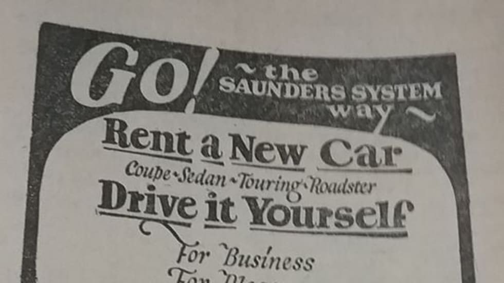
This Is the Oldest Car Rental Advertisement You’ll Ever See
This ad for Saunders Drive it Yourself, believed to be the first car rental company in the U.S., was found in an Omaha phone book from 1926.
Read More →
The Desk Upsell Is Costing Operators More Than it Earns
Counter upsells generate revenue, but they can also slow transactions, erode trust, and cost repeat business. Fully inclusive pricing may offer operators a better path to long-term value.
Read More →
U-Save Expands Indian Ocean Presence with New Master Franchise for Mauritius
The franchise has been acquired by Mauritian travel entrepreneur Umarfarooq Omarjee, an established figure in the island's tourism and mobility sector.
Read More →
Global Carsharing Fleet Projected to Reach 768,000 Vehicles By 2030
A new Berg Insight forecast outlines several business models driving the projected growth in public carsharing worldwide through 2029.
Read More →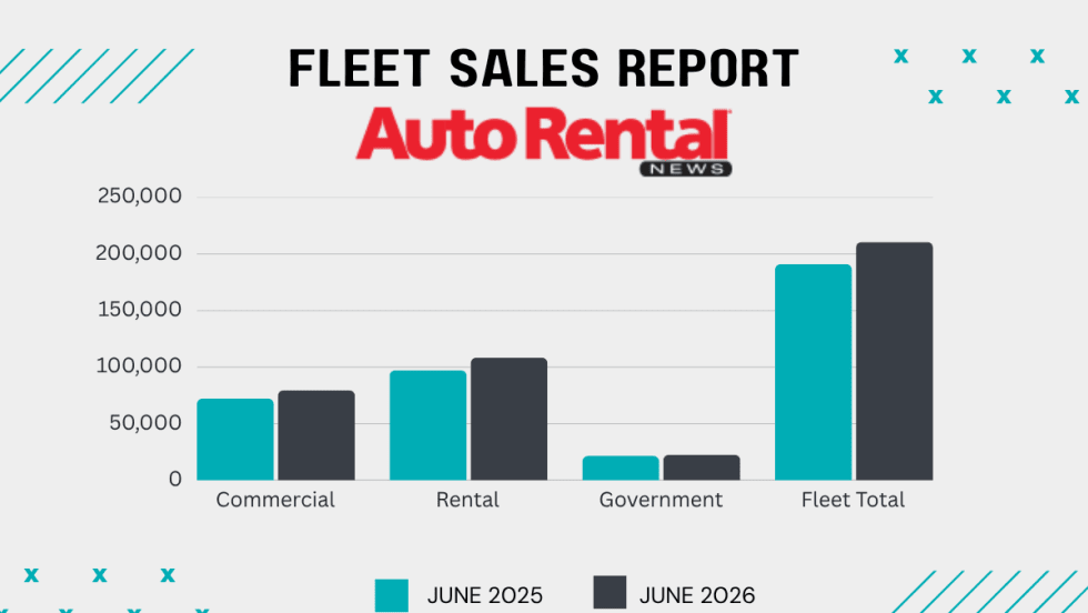
Rental Car Fleet Sales Show Mid-Year Strength
June gains ensured rental fleets closed out the first half of 2026 in positive territory.
Read More →
Surprice Mobility Opens Corporate Rental Station at Milan Malpensa Airport
The Milan opening is part of Surprice Mobility's broader strategy to expand its corporate operations while increasing the use of technology across its network.
Read More →
Brazilian Executive MBA Targets Growing Domestic Rental Car Industry
Rental car companies face a unique combination of challenges that are rarely addressed in traditional programs.
Read More →
Green Motion Expands Into Japan With Master Franchise Agreement
Japan's tourism industry, business travel market, and demand for vehicle rental services are reasons the country represents an important market for the company.
Read More →